Posts

Showing posts with the label pct

Kindle Once Again - this time for Walk, Hike, Saunter
Image
 Last time I did this was Dec 2017. At the moment, memory of how to do it is pretty foggy, but luckily I have my earlier blog posts on this to refresh my memory so printing them out to review. (look for Kindle label in this blog to find).  This book is a little easier than the others - text and inline photos, a table of contents, but no index. Susan has promised it will be out in two and a half weeks, so will try to do that. My immediate issue is that I remember that I have to make some changes to the Indesign file before putting out the epub file that I will update for Kindle, but don't remember quite what they were. Pausing to read my prior posts, and to review Kindle code for Healing Miles . From my 2012 notes I saw that to get reliable chapter breaks, each chapter had to be a separate xhtml file. The default of Indesign is to put out one big xhtml file, but it will break on a style, so I need to be sure the current Indesign document (for Walk, Hike, Saunter ) has an appro...
Feeling a lot of empathy for those PCTers in Washington right now

Image
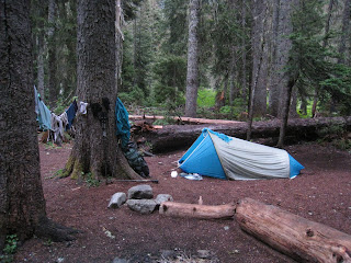
The Dinsmores, and the pct-l forum report lots of rain. Fortunately the resupply points are five to seven days apart for strong hikers, so if everything is wet by the fifth day, just a day or two more till you reach civilization. I've already sent off my Stephenson's Warmlite to get endliners, which will reduce condensation in the front and back of the tent, should we ever be so foolish as to ever attempt such a trip again. I'm still investigating how to cook in the tent - seems risky at best. Even if we don't burn our shelter down, how much oxygen do two people need in a Warmlite, and how much is used up if you take 7 minutes to boil a liter of water in the tent? Maybe I should get one of those carbon monoxide warning devices, put it in the tent while we boil a pot of water.

Completed Pacific Crest Trail, Sept 7, 11:10 am

Image
A long time coming, but we finally reached the monument marking the Canada-US border. Our first segment of the trail was in 1989, but we have done the majority of it since 2004, in a couple of 200 to 300 mile trips each year. This year we decided we didn't know how long we could keep doing this, so did the last 470 miles in one 5 1/2 week trip. It's way too much stuff to put in a single blog post, so I'll just post from time to time on whatever comes to mind about the trip. One is that Washington weather is different, particularly northern Washington. If I lived up there I would have to rethink my gear for wet conditions. We had rain and snow, which we've experienced before, but never with days on end with no sun or wind to dry things out. Our waterproof socks made things comfortable as long as we could start the day with dry liners, but by the end of five days, all socks were wet, tent was wet, fleece was a little damp, down bag a little damp and we were a little we...

Trips, treks, tramp of time

Image
This is a big year for us. Finally completed the Torres del Paine circuit in March, in June do the last segment of the Arles Route over the Pyrenees into Spain, and in Aug-Sept complete the 2600 mile Pacific Crest Trail, starting near the southern border of Washington state and reaching Manning Park in Canada about 40 days later. Along with that we are trying to keep up our connections with friends and relatives, and Susan needs to attend to the needs of her 99 year old and somewhat independently  living mother. Not to mention normal house maintenance. It is difficult to keep on top of everything. Yesterday looked at detailed daily mileage for the Pcific Crest Trail trip to get exact time for trip and location of resupplies. Today I checked the flight to France to see whether we arrived in time to go on to Oloron Sainte Marie the same day. Yes, barring delays so querying hotel in Oloron for reservations. Our calendar every day says "walk". Today there was a note: Carry bac...

Pacific Crest Trail - this year's trip

Image
Toads, slugs, volcanos. People say that Oregon is just a fast long green break on the way to Canada, but that is not the way we found it. Some truly spectacular mountain wilderness areas - The Sisters, Mt. Washington, Mt. Jefferson, Mt. Hood, to mention the main ones. It might have been 100 degrees down in Bend, but we had about a week of hiking most of the day in below 40 weather. Still, the ghostly appearance of 100 foot trees shrouded in the fog is worth seeing. Even Mirror Lake was beautiful, with mist rising off of it, and not a mountain reflection to be seen, not even the far shore. This year we started at highway 58 in Oregon, just past Lake Odell, and finished in Panther Creek Campground, about 3 days into Washington. In Southern California, lizards are always zipping away from your feet at the last minute. In Oregon it was small toads. Their color varied according to the terrain, but all had a faint yellow stripe down the back. Days later we went through a stretch where...

Digital looks like a classy lady, slides like a lady of the night

Image
We've been taking digital for five years now, and I finally got back to scanning in a 2004 PCT trip that was originally slides. As I wiled away a few hours doing this, I realized a couple of things. First, how few slides we took on a backpack trip, compared to what we do now. We had to ration ourselves to something like six slides a day. It just cost too much to to more than that, so we missed taking a lot of things I wished we had. The other thing is that I realized that I like the digital images better. The slides are sort of like the streetwalkers we see in the marginal areas of the city. An in your face attraction to them, but over done. The colors are over bright, the contrasts too great. It makes a good show, but the natural look is more to my taste. As I look at this post in 2020, I realize it is sort of a flippant male attitude, joking about women and their appearance. Nowadays I would be more thoughtful, but that was my thought back then, so I will let it stand.  Insert ...

Caldecott Wildlife Corridor - perfect PCT training hike

Image
From our house in the Oakland East bay hills, we walk up past Sibley Volcanic Regional Preserve, where we join the Bay Area Ridge Trail/East Bay Skyline Trail and walk to the Train Station in Tilden Regional Park. The round trip is about 10 miles for us, about 7 miles if you start from Sibley. You are walking through the Caldecott Wildlife Corridor for most of the way, and a relatively untraveled, pristine trail for much of its length. The trail elevation profile is quite similar to what you find on the PCT. Do this with a 25 lb backpack from Sibley and you will feel it. Start at the Pinehurst Road - Skyline intersection, just a mile or so south on the Ridge Trail, and it will kick your butt if you do it round trip. I saw a mountain lion on this section south of Sibley when I did it earlier this year. Over the course of a year, we do on the order of 200 miles on this trail. I've made some attempts at trail maintenance with varying success. There is a fair amount of poison oak, ...

First time in five years not crawling out of a tent on the PCT at 4:30

Image
Early this morning, as I was returning to bed after a bathroom visit (I do this more now than when I was younger), the clock showed 4:30, and through the bedroom window, there was just the slightest hint of dawn. The light and the hour gave me a sudden déjà vu. I realized that this was the first time in five years I was not crawling out of a tent somewhere on this date and time. I searched through our photos to see just what we had been doing around this time on prior years. PCT Section B 2005 May 10 PCT Section C 2006 May 10 PCT Section D 2007 - May 2 Hiker Heaven PCT 2008 - May 13 Butterbredt Canyon Road 2009 - May 10 Squirrel on our feeder, new solar fan installation We've been working our way through the southern California desert on the Pacific Crest Trail since 2005. My routine for this date and time for the prior four years has been: get out of the sleeping bag, stuff it, throw all my gear outside the tent and crawl out, all without getting on Susan's side ...

Long Distance Walk Planning

Image
I'm just finishing up a planning effort, both polishing up our GR 653 Arles to Toulouse info based on completing that trip, and doing the initial Toulouse to Puenta la Reina planning. In all cases, the key document is the spreadsheet in the bottom center of the image. Normally I will use a Google Documents spreadsheet, as I share the info with others. I gather the appropriate guidebooks, and from them build the spreadsheet with names of the stops, and distances between points. To this I add the elevation for each point. Sometimes this is in the guidebooks, other times I have to pull it off of a topo map, or my topo software, or worst case, zooming google maps in terrain mode. I add cumulative distances to my spreadsheet, and with the distances and elevation can do an elevation profile chart with Google charts. Its a little easier to chart if I clone my original spreadsheet, and delete all but the elevations and cumulative distance. An aside, we've been getting some unattribu...

Pacific Crest Trail Section or thru-hiking - an extreme sport

Image
No doubt about it. Consider your normal recreational backpack - hike six hours, find a beautiful campsite, hangout, bag a peak, read, swim, photograph, etc. Definitely a vacation. Active, yes, but if asked what you did for vacation, you answer "went backpacking" with no hesitation. Now, our recent 300 mile section hike on the PCT. Up at dawn - roughly 5:30. On the trail by 7. Gorp break at 9, PopTart break at 10:30, jerky, powerbar, dried fruit & cracker for lunch, Gorp breaks thru the afternoon & finally finding a suitable camp spot at 7pm. A dry camp of course. You only hit water once or twice a day, and rarely is it when you want to camp. So, on the last water, pump about 3 liters extra for supper and breakfast at the dry camp. Some days we might stop at five pm. On those days the thru-hikers will be going by, sometimes saying "stopping early?" as they go on to complete their 30+ mile day. So why do we do it? Because it feels so good to stop? Possibly ...