Posts

Showing posts with the label oakland walk

Kindle Once Again - this time for Walk, Hike, Saunter
Image
 Last time I did this was Dec 2017. At the moment, memory of how to do it is pretty foggy, but luckily I have my earlier blog posts on this to refresh my memory so printing them out to review. (look for Kindle label in this blog to find).  This book is a little easier than the others - text and inline photos, a table of contents, but no index. Susan has promised it will be out in two and a half weeks, so will try to do that. My immediate issue is that I remember that I have to make some changes to the Indesign file before putting out the epub file that I will update for Kindle, but don't remember quite what they were. Pausing to read my prior posts, and to review Kindle code for Healing Miles . From my 2012 notes I saw that to get reliable chapter breaks, each chapter had to be a separate xhtml file. The default of Indesign is to put out one big xhtml file, but it will break on a style, so I need to be sure the current Indesign document (for Walk, Hike, Saunter ) has an appro...
Trail of 4 Cities Meander

Image
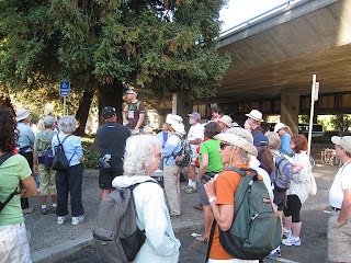
Who knew. I took part in an urban hiking event Sunday, little knowing that I was participating in a pedestrian critical mass. For those of you in my extended audience, Critical Mass is an anarchist sort of bicycle gathering monthly in San Francisco. Through sheer volume, they take over streets, roll through stop signs and red lights, causing consternation and curses in the unaware motoring public. I live in a belt of cities along the east shore of San Francisco Bay. I'm in Oakland, the one of which Gertrude Stein said "there is no there, there". A gross slander, by the way. To the north is Berkeley of international fame, University of California, student dissent, etc. and my alma mater. North of that is a little wedge called Albany, which  we will forever after ignore in this post, then an upscale community - Kensington. We got married in the First Unitarian Church of Kensington, only for some reason, they call it the First Unitarian Church of Berkeley. And, Finally, E...

Oakland Hills Walk 5 - North Oakland Sports Center loop to Skyline & Old Tunnel Rd

Image
The Caldecott Tunnel through the east bay hills is a critical commute corridor for those east of the hills. Initially roads wound over the hills. In 1903 a tunnel was built above the current tunnel location, and when this walk takes you on Old Tunnel Road, that's the origin of the name. The current tunnel started with two bores in 1937, added a third in 1964, and a fourth is budgeted. In 1982, a gasoline truck caused a firestorm within the tunnel, killing seven, and in 1991 an improperly extinguished grass file just above the tunnel caused the disastrous Oakland fire that killed 25 people. I have driven through this tunnel many times, and had to evacuate for the fire, so know this area well. As you approach the tunnel from the west, you see a lot of houses on the left side, and on the right, eucalyptus, brush, and a high voltage power line on the crest of some hills. Several years ago,  a sports field facility was built on the right side at the base of ...

Oakland Hills Walk 3 - Merriewood Steps - Figure 8 - 1.1 miles

Image
This is longest stretch of interconnected steps that I know of in Oakland. About 400 steps and a climb/drop of two hundred plus feet in about a third of a mile. It makes a good workout, particularly when you do two steps at a time on the steep sections. These steps were restored in 2003 , so they are in good shape. View Oakland Hills - Merriewood Steps - the figure 8 in a larger map Thirty to forty years ago, I lived on the top of Merriewood, and commuted to the city. A bus came down Upper Broadway Terrace and stopped right at Merriewood, so usually an easy trip down to Montclair Village and the express from there. However, one winter I had a different schedule, forcing me to catch the early express from Thornhill and Mountain, and the fast way down was the Merriewood stairs, in their unrestored condition. Broken steps, missing steps, fortunately the handrail was usually intact. That was a cold and wet winter, and there were several weeks where the steps were covered with ice. More...

Oakland Hills Walk 2 - Rockridge BART Loop via Montclair Village Steps 9.5 miles

Image
My GPS says 9.8 miles, my cleaned up Google track says 8.7 miles. Total ascent about 1040 feet. If you start near the top like I do, it is a nice stroll down through the hills and secluded streets to BART and then a fairly good workout back by Lake Temescal and up through the Thornhill Canyon. I look for one of a kinds and the sort of strange as I walk, and this route offers a few, mixed in with the ostentatious and conservative. View Oakland Hills Walk 2 - to Rockridge BART in a larger map Starting down from Hemlock St & Lodge Ct go a few blocks on busy Colton. Just before you turn left on Heartwood keep your eye open for the yard with the merry-go-round horse on the left. For a while, retrace the Oakland Hills walk 1 down to Mountain Blvd and Montclair Village. On a weekday you will hear Montclair Elementary about three blocks away. Amble north on Mountain past the school and checkout the library a little later. Now left on Thornhill and cross under highway 13, turning ...