Posts

Showing posts with the label oakland

Kindle Once Again - this time for Walk, Hike, Saunter
Image
 Last time I did this was Dec 2017. At the moment, memory of how to do it is pretty foggy, but luckily I have my earlier blog posts on this to refresh my memory so printing them out to review. (look for Kindle label in this blog to find).  This book is a little easier than the others - text and inline photos, a table of contents, but no index. Susan has promised it will be out in two and a half weeks, so will try to do that. My immediate issue is that I remember that I have to make some changes to the Indesign file before putting out the epub file that I will update for Kindle, but don't remember quite what they were. Pausing to read my prior posts, and to review Kindle code for Healing Miles . From my 2012 notes I saw that to get reliable chapter breaks, each chapter had to be a separate xhtml file. The default of Indesign is to put out one big xhtml file, but it will break on a style, so I need to be sure the current Indesign document (for Walk, Hike, Saunter ) has an appro...

A long, familiar walk, but always some new images

Image
When Susan and I are training, or these days, when Susan is still recovering and my body needs to walk, we have a local walk of about ten miles. The incentive is a local bakery, five miles away. A croissant and a coffee primes us for the return. The bakery is at 300 feet elevation, we are at 1100, so mostly down for the first half, and up all the way back. This is a two or three times a week trip, so we seek out little variations, always keeping in mind the distance to the nearest restroom. That means keeping tabs on any construction going on midway either direction, and the associated porta-potty. One of the variants goes down the bear route, where three wood sculptured bears are to be along the way.   This last walk was my day for yards with character or at least interest: They continue up the driveway, representing many happy hours We are having a drought year, so this brown metal sculpture blends right in. A block or two further on This rout...

Trail of 4 Cities Meander

Image
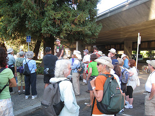
Who knew. I took part in an urban hiking event Sunday, little knowing that I was participating in a pedestrian critical mass. For those of you in my extended audience, Critical Mass is an anarchist sort of bicycle gathering monthly in San Francisco. Through sheer volume, they take over streets, roll through stop signs and red lights, causing consternation and curses in the unaware motoring public. I live in a belt of cities along the east shore of San Francisco Bay. I'm in Oakland, the one of which Gertrude Stein said "there is no there, there". A gross slander, by the way. To the north is Berkeley of international fame, University of California, student dissent, etc. and my alma mater. North of that is a little wedge called Albany, which  we will forever after ignore in this post, then an upscale community - Kensington. We got married in the First Unitarian Church of Kensington, only for some reason, they call it the First Unitarian Church of Berkeley. And, Finally, E...

Joys of Walking in the Rain

Image
As I write this we are having a brief respite from the flash-boom thunderstorm right overhead. I know this is common for many of you, but for we in the Oakland Hills on the east side of San Francisco Bay, a few times a year occurrence. A smattering of hail on the ground, and no birds in sight. Earlier, when it was just windy and raining, birds were all over the place, a dozen or so trying to get on our cylindrical feeder with eight perches. Our plan for today was a two hour hike, regardless of the weather, so this morning we put on our rain pants, packs, rain parkas, etc. I even put on my Seal Skinz waterproof socks. Our route was one of our favorites, the Heaven Hill & Pacific RR route  I blogged about earlier. We had just donned the same gear a couple of days ago to go on the Kings Canyon Loop , a familiar local water district trail. On both of these trips there was rain, wind, mud .... and we had a whole lot of fun. There is a lot of in the moment stuff, small...

Oakland Hills Walk 5 - North Oakland Sports Center loop to Skyline & Old Tunnel Rd

Image
The Caldecott Tunnel through the east bay hills is a critical commute corridor for those east of the hills. Initially roads wound over the hills. In 1903 a tunnel was built above the current tunnel location, and when this walk takes you on Old Tunnel Road, that's the origin of the name. The current tunnel started with two bores in 1937, added a third in 1964, and a fourth is budgeted. In 1982, a gasoline truck caused a firestorm within the tunnel, killing seven, and in 1991 an improperly extinguished grass file just above the tunnel caused the disastrous Oakland fire that killed 25 people. I have driven through this tunnel many times, and had to evacuate for the fire, so know this area well. As you approach the tunnel from the west, you see a lot of houses on the left side, and on the right, eucalyptus, brush, and a high voltage power line on the crest of some hills. Several years ago,  a sports field facility was built on the right side at the base of ...

Oakland Hills Walk 4 - Heaven Hill and Pacific Railroad Loop 3.5 miles

Image
HH&PRR is about half way along this loop if you start at Lodge and Hemlock, but it is one of the highlights. I'll talk more about it and carofthefuture.org later. One of our frequent hikes is north along Skyline to Sibley, and from there onto regional park trails. In Jan 2008 there were severe storms, and a slide blocked Skyline Blvd to all traffic, including pedestrians. In searching for an alternate way to Sibley and Huckleberry, I discovered the HH&PRR route, though didn't have a name for it at the time. The weather was still wet and stormy, so I took the closest surface I could find to the slide, and followed it north, at each intersection, choosing the rightmost (eastern) street, as that kept me closest to Skyline Blvd. It is about half through shaded small residential streets, and then climbs along undeveloped parkland (where I frequently see turkeys). That parkland is on the left. The right is steep and lightly developed, but for sale signs are posted, and s...