Posts

Showing posts with the label Continental Divide Trail

Kindle Once Again - this time for Walk, Hike, Saunter
Image
 Last time I did this was Dec 2017. At the moment, memory of how to do it is pretty foggy, but luckily I have my earlier blog posts on this to refresh my memory so printing them out to review. (look for Kindle label in this blog to find).  This book is a little easier than the others - text and inline photos, a table of contents, but no index. Susan has promised it will be out in two and a half weeks, so will try to do that. My immediate issue is that I remember that I have to make some changes to the Indesign file before putting out the epub file that I will update for Kindle, but don't remember quite what they were. Pausing to read my prior posts, and to review Kindle code for Healing Miles . From my 2012 notes I saw that to get reliable chapter breaks, each chapter had to be a separate xhtml file. The default of Indesign is to put out one big xhtml file, but it will break on a style, so I need to be sure the current Indesign document (for Walk, Hike, Saunter ) has an appro...
CDT - Southbound - Glacier National Park section hiker's reconnaissance

Image
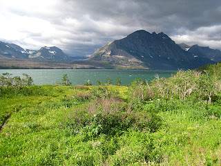
You have a couple of choices for a southbound CDT route through Glacier. The first starts in Waterton Lakes National a Park in Canada, crosses the border at Goat Haunt, and follows the Highline trail through Glacier. This route is open at the earliest around Aug 1, as it depends on snow conditions and the Ahern Drift trail segment being blasted out. The second starts at the Chief Mountain Customs Station. The trailhead is about 50 yards south, and has a large parking lot. When we were there around 7/21 there were about 40 cars there. This route goes to Belly River, then Elisabeth Lake. After that you can go via the Ptarmagan tunnel if it is open, or the longer route via Poia Lake to Many Glacier (a resupply point with store, motel, etc.). There is not a lot of car access to the park. It is divided north south by the Going to the Sun Highway, which starts in St. Marys and ends at West Glacier. The CDT crosses this highway at two different points, depending on your route. You can pro...