Posts

Showing posts from February, 2009

Kindle Once Again - this time for Walk, Hike, Saunter

Image
 Last time I did this was Dec 2017. At the moment, memory of how to do it is pretty foggy, but luckily I have my earlier blog posts on this to refresh my memory so printing them out to review. (look for Kindle label in this blog to find).  This book is a little easier than the others - text and inline photos, a table of contents, but no index. Susan has promised it will be out in two and a half weeks, so will try to do that. My immediate issue is that I remember that I have to make some changes to the Indesign file before putting out the epub file that I will update for Kindle, but don't remember quite what they were. Pausing to read my prior posts, and to review Kindle code for Healing Miles . From my 2012 notes I saw that to get reliable chapter breaks, each chapter had to be a separate xhtml file. The default of Indesign is to put out one big xhtml file, but it will break on a style, so I need to be sure the current Indesign document (for Walk, Hike, Saunter ) has an appro...

Snow in Sunol and Hair Snakes

Image
After a very long dry spell, we are finally getting days of rain, beating down, pound on the roof, flashes of lightning, rain. I'm not complaining. The reservoirs are still only 67% of what they should be - rain is good. However, it somewhat complicates our training efforts. Sometimes we don the rain pants, rain jacket, even sometimes waterproof socks, and venture out on our usual trails. Of course we still use our running shoes, and they sometimes come back caked with mud. Our hiking poles are vital for keeping us erect. Sometimes, though, we are lazy. Where can we hike in the rain and avoid the mud? We have some routes on the local streets that are interesting, and we may do them, but eventually we have to get out of town, and into the open spaces. Sunol Regional Park is one of our favorite wet weather hikes. They have a gravel road that runs out beyond Little Yosemite, and we can get a good 6 mile hike by following that out and then up to the gate for the back country route t...

Turkeydactls in Berkeley?

Image
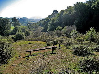
This was a week or two ago, but I finally captured my photos. Even though digital is so easy compared to film, I still have to read them in, use RenameMaster to change the filename to date and time, and move from staging folder to final folder. All I can show is the bench where the following occurred. You have to fill in the birds. I was out doing my usual long distance training hike, our house to Huckleberry Reserve, to Sibley Regional Park, to the Tilden Train station and back again. About 10 miles. Anyway, as you near the Tilden end, there is a bench just off the trail, where you can sit and look at miles of rolling hills, at least until the Orinda housing project completes. This time, as the bench came into sight, about 40 feet away, there was a large flock of turkeys around the trail and bench - 35 to 40 of them. I slowed down, and got to within about 20 feet and they all took off - fifty feet off the ground immediately and then flapped and then glided, silhouetted against the d...