I forget (block out?), over time, the more trying aspects of a trip. Unless, of course, it was so terrible that I have a story to tell at appropriate occasions. We have a story to tell for part of this route, that I will hold for another time, or possibly never tell. However....
We are blessed (that word has religious overtones, but I just mean an earlier, intelligent set of voters), with a vast system of regional parks, home to coyotes, foxes, mountain lions, raptors, rattlesnakes, newts, spittle bugs and beetles, to name a few. Berkeley was the scene of radical politics in the 60s, and those matured radicals still have a positive effect on their local environment, though the fuddy-duddys are gaining.
I digress. The Ohlone Wilderness Trail has a segment between Del Valle Regional Park and Sunol Regional Park that is about twenty miles long. Starting from Del Valle, at about 750 feet elevation, it is ten miles to Maggie's Half Acre campsite at elevation 3480. This is by any standards, a non trivial hike. Add to that the fact that in the middle of the ascent, there is a four hundred foot drop into a canyon, and then an ascent out, altogether about a 3000 foot climb in ten miles. From Maggie's half acre out, it is another ten miles, but mostly down, with quite a few PUDs in between (pointless ups and downs). We did this as an overnight backpack in 2007, and again a few days ago. This time it was near 80 degrees F. Consequently I took no pictures until we were near the top of the climb. It was a b--- buster, or make your own euphemism.
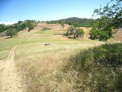 |
| Finally near the top |
Near the top the trail levels off; you walk through a pine forest, and interspersed are these huge oak trees, I estimate eight feet in diameter. For this country, that is huge. I saw the trees last time, but again this time, I was so exhausted that I couldn't raise my camera. Once more they go unrecorded.
The climb from there was more gradual to Maggie's Half Acre, so by the time we setup camp, I had the energy to take a few pictures. I skipped the outhouse, which was colorful, but gross. This location has three campsites (which you must reserve in advance). #2 was ours, #3 was nearby. Both were ok, but the next morning we finally saw #1 - the best location for ambiance, but farthest from the water.
|
This is the tent we carried for Camino Mozarabe, but never used
|
 |
| Evening View West |
 |
The evening at campsite
The next morning, took some shots as we worked our way down. The following are from that morning:
|
 |
The next morning
|
Obligatory Morning Shadow Picture
 |
Wildlife of the herp variety
 |
Not so wildlife
 |
Morning Trail
 |
| End of the Trail |
|
Don't know what this was - fawn, calf? no skull around.
This whole trail is an hour's drive from my house to one end, where we drop a car. Drive fifty minutes and we are at the other end, ready to start. Just a sample of what we have to offer in the San Francisco Bay Area.
|
|
|
|


Now that I have completed it, I love this hike! Best done when not too hot, little did we expect 80s and 90s!
ReplyDeleteLooks wonderful!
ReplyDelete